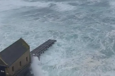
A severe yellow weather warning for strong winds and heavy rain disrupted weekend travel and outdoor events across southern England on Saturday, June 6, 2026.
The Met Office issued the alert from 9:00 AM to 9:00 PM BST, warning that gusts between 45 mph and 50 mph could reach 55 mph in exposed areas.
>>> FBI Adds Minnesota Fraud Suspect to Most Wanted List
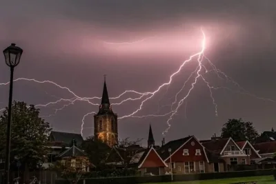
An unseasonable low-pressure system swept through coastal districts, causing power outages and event cancellations.
A fallen tree downed electricity cables on the A272 in East Sussex, leading to power cuts.
The Royal Cornwall Show's final day, the Durrington Festival, and a barn dance in Ditchling were all canceled due to the weather.
The sudden downturn follows a significant temperature drop, with London hovering around 16°C just ten days after Kew Gardens recorded a historic May heatwave peak of 35.1°C.
Meteorologist Details Conditions
Linda Ludlow, BBC South West broadcast meteorologist, described the weather as "unseasonable June weather with persistent rain and strong winds."
She noted that a peak gust of 51 mph had already been recorded on the Isles of Scilly as the system moved eastward.
"Our peak recorded gust so far this morning as the occlusion went through was 51mph on the Isles of Scilly," she said.
Ludlow explained that conditions would clear in Devon by mid-afternoon, transitioning into a breezier but drier Sunday.
"The associated heavy and persistent rain will sweep east for the rest of the morning," she said.
She added that western areas would see sunnier intervals later in the day.
"Brightening up in the far west with sunny spells and will clear Devon by mid-afternoon with the wind becoming more westerly, fresh to strong, by late afternoon," Ludlow said.
She concluded that it would be less windy overnight, with a breezy but drier and brighter day on Sunday with cloudy skies.
Met Office Warns of Disruption
A Met Office spokesperson highlighted the widespread operational challenges posed by the coastal gale system.
"Some disruption to weekend activities and events is possible, alongside a risk of power outages and some low level travel disruption," the spokesperson said.
>>> EO Jongerendag 2026 Broadcast Schedule: Fearless Generation Theme
The national weather service detailed the storm's movement across English Channel districts toward the southeastern coast.
"Winds will steadily move eastwards across English Channel coastal districts, reaching Sussex by mid-afternoon," the Met Office stated.
Forecasters specified the geographical reach of the high-velocity gusts as they advanced through the day.
"These will steadily move eastwards across Cornwall, English Channel coastal districts, and the Isle of Wight, reaching Sussex by mid-afternoon.
Winds will then begin to ease from the west," the Met Office added.
Chief Meteorologist Chris Bulmer provided a broader national perspective on the weakening but volatile front moving across the United Kingdom.
"Over the next few days we’ll continue to see a fairly changeable picture, with a mix of sunshine and showers for many.
Into the weekend, a more organised area of rain and stronger winds will move across the UK, although this system is likely to weaken as it does so," Bulmer said.
He summarized the upcoming atmospheric patterns, noting the intermittent nature of the precipitation.
"While some heavier rain and gusty conditions are possible at times, the overall picture remains one of changeable weather, with further spells of rain or showers interspersed with some drier and brighter periods," he said.
Met Office spokesperson Andrea Bishop contextualized the sharp temperature contrast in London relative to standard June patterns.
"Following last week’s heatwave, this weekend will feel notably cooler for London, with temperatures returning to nearer the seasonal average and a more changeable feel," Bishop said.
She added that while many will see sunny spells, cloud will build bringing a small chance of isolated showers later, with a maximum temperature of 18°C predicted.
>>> EO Jongerenday Marks 50th Anniversary with Two-Day Celebration in Rotterdam
Through the weekend and into next week, conditions turn more unsettled at times, with outbreaks of rain, breezy periods, and temperatures hovering around or slightly below normal.