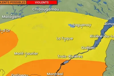
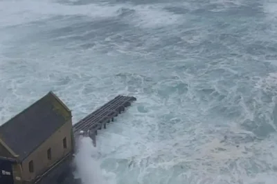
A cold front sweeping across Quebec on Saturday, June 6, 2026, is expected to bring severe thunderstorms, torrential rain, and damaging winds to several regions, including the greater Montreal area, Outaouais, and Abitibi-Témiscamingue.
The weather system follows a period of tropical temperatures and will dump 20 to 40 millimeters of rain across southern parts of the province.
>>> Labrador Island Link Trip Causes Power Outages for 73,000 in Newfoundland
Areas east of Sept-Îles could see accumulation totals exceeding 50 millimeters by Sunday evening.
Storm Risks and Warnings
Meteorologist Patrick Duplessis noted that while the eastern region of Sept-Îles will face heavy downpours, the risk of electrical storms there is significantly lower than in western and southern sectors.
Atmospheric energy building up through Saturday evening is projected to intensify storm cells as they move from northeastern Ontario toward Abitibi and southern Quebec.
>>> Mélissa Bédard Slams Quebec Restaurant for Threatening to Remove Her Family
This will create hazardous conditions during the afternoon and evening.
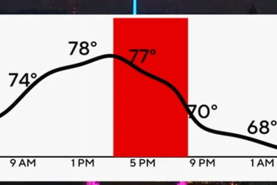
Duplessis highlighted two impulses to watch that could generate small hail during the most intense storms, but more importantly, strong gusts that could reach 90 km/h.
Forecasters confirm that these wind gusts meet the official criteria for a severe thunderstorm classification.
>>> Three Men Jailed for UK Postal Drug Network from Bury Warehouse
A humid heatwave is projected to follow early next week.