The Met Office has warned that intense thunderstorms are heading toward Northern Ireland as an exceptional May heatwave, which broke historical temperature records, begins to subside.
Weather pattern transitions will bring cooler conditions across the United Kingdom following a period of unprecedented spring heat.
>>> Oakridge Park Opens 500,000 Sq Ft Retail Hub in Vancouver
Meteorological data indicated that extreme temperatures peaked earlier this week before shifting toward a more unstable atmospheric pattern.
"Normal service resumes as June begins," stated Aidan McGivern, a Met Office meteorologist, who noted the preceding weather was truly historic and exceptional.
Forecasters tracked a gradual breakdown of the high-pressure system that brought the high temperatures. The changing conditions are expected to introduce moisture and instability across the region.
"After another few hot days, a gradual cooling trend is expected by the start of June," McGivern added.
Regional Forecast for Northern Ireland
Regional forecasts for Northern Ireland outlined a transition from dry conditions to scattered precipitation.
Wednesday evening was projected to remain mostly dry with a slight chance of late showers.
According to the Met Office Northern Ireland, the weather on Wednesday was "mainly dry, sunny and warm" while the evening "will be mainly dry but the odd shower possible later on."
Thursday is expected to bring variable cloud cover along with some sunny intervals.
Temperatures will remain warm, reaching a maximum of 23 °C, though isolated showers could develop early in the day and return during the evening hours.
The Met Office Northern Ireland stated that Thursday will be "a mostly dry day with variable amounts of cloud and some bright or sunny spells."
The agency noted that the conditions would remain warm but described the day as having the "odd shower possible first thing, and again in the evening."
The weekend outlook indicates a further shift toward unsettled weather patterns.
Friday is expected to start cloudy before clearing, while Saturday will bring a higher probability of continuous rain.
According to the Met Office Northern Ireland, the outlook for Friday to Sunday begins with a "cloudy start with the odd shower on Friday, then dry and brighter by afternoon."
>>> Amazon MGM Studios Moves Voltron Movie Directly to Prime Video
The weather agency added that conditions would turn "cloudy on Saturday with outbreaks of rain" followed by a period that will be "mainly dry on Sunday."
Record-Breaking Heat and Long-Range Outlook
The impending storms follow a series of weather warnings issued by Met Eireann across multiple counties in Ireland.
Yellow heat warnings were implemented from midday Tuesday until 6 p. m.
Wednesday after temperatures surpassed historic May maximums.
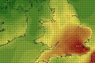
Met Eireann reported that provisional data on Tuesday showed temperatures reaching 30.5°C at Shannon Airport, which officially broke a previous May record of 28.4°C set in Co Kerry in 1997.
Unofficial observations at automatic climate stations recorded 30.7°C in Clonmel on Tuesday afternoon.
The agency issued warnings regarding heat stress, uncomfortable sleeping conditions, elevated forest fire risks, and water safety concerns at public beaches and lakes.
In Northern Ireland, the highest recorded temperature during the peak of the heatwave reached 25.8°C at Derrylin, Cornahoule on Monday.
Long-range forecasts indicate that changeable conditions will persist well into the first week of June.
Atlantic weather systems moving from the west are expected to bring a recurring mix of rain and brief dry spells.
Regarding the period from Monday, June 1 to Wednesday, June 10, the Met Office Northern Ireland stated it will be "a changeable period, as a sequence of Atlantic weather systems move in from the west to bring a mixture of drier spells and some showers or longer spells of rain at times."
The weather service explained that western and northwestern areas will experience more frequent rainfall compared to southern and eastern regions.
"The best of the drier conditions are more likely towards the south and east, with the rain generally more frequent in parts of the west and northwest, although there will be drier interludes here also," the Met Office Northern Ireland stated.
The agency concluded the mid-term forecast by detailing expected regional temperatures and wind conditions. "Temperatures will be near-normal overall, with the warmest spots most likely across eastern areas.
It will also be breezy at times, most especially across northwestern areas," the Met Office Northern Ireland stated.