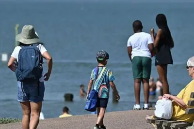
The Met Office has forecast a temporary cooling trend across northern and eastern parts of England on Wednesday, May 27, 2026.
Temperatures in these regions are expected to drop by approximately 10 degrees Celsius following a historic spring heatwave.
>>> Netflix Faces Backlash Over Alleged AI Errors in Enola Holmes 3 Poster
Maximum temperatures in the affected areas will range between 19C and 23C before rising again later in the week.
This comes after consecutive days where parts of southeast England exceeded 34C, and Kew Gardens in London set a new national May record of 35.1C on Tuesday.
Heatwave Definition and Causes
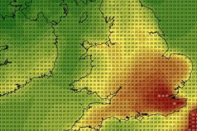
The Met Office defines an official heatwave as a period where an area experiences a specific high-temperature threshold for at least three consecutive days.
These thresholds vary across the UK due to regional climate differences. London requires temperatures of at least 28C for three days to meet the criteria.
A persistent high-pressure system known as a "heat dome" has trapped warm air over Europe, driving the unseasonable spring weather.
>>> Chris Kamara Opens Up About Speech Apraxia on Good Morning Britain
Professor Ed Hawkins, a climate science expert at the University of Reading, told the BBC that "heat events are emerging earlier, intensifying faster and occurring across a much warmer background climate."
Historical data shows that temperatures have rarely reached 30C during May since UK record-keeping began.
BBC Weather Meteorologist Simon King noted that while London and southeast England will still see temperatures up to 27C, it won't be the 28C needed to officially continue the heatwave.
Wales and southwestern England are expected to remain hotter, isolated from the incoming cooler air, with local highs potentially reaching 30C.
>>> Record Heatwave Strikes UK, Triggering Health Alerts and Disruptions
By Thursday, the cooler air supply will be cut off as hot air surges back from France, bringing temperatures back up to 30C.