Residents across the Susquehanna Valley began clearing widespread storm damage on Sunday, June 7, 2026, as a tracking cold front ushered in lower humidity and more comfortable conditions.
The local weather shift followed severe evening weather that left numerous trees and power lines down throughout the region.
>>> Nottingham Attack Families Demand Accountability Over Systemic Failures
According to the WGAL News 8 Storm Team, regional emergency crews and residents responded to more than 67 reports of downed trees and power lines.
The damage followed a line of storms that moved through south-central Pennsylvania the previous evening.
A cold front moving south is drawing drier air into the area, causing dew points to drop from the mid-60s into the 50s.
Meteorologist Maryellen Pann reported that northwest winds blowing at 10 to 15 mph are helping settle a more comfortable air mass into the region.
"Our live local eight scan is showing dry conditions across the area, so we'll have an opportunity to get out and clean up after storm damages," stated Maryellen Pann, Meteorologist for the WGAL News 8 Storm Team.
>>> World Cup to Trigger Record British Electricity Demand
The dry conditions will keep afternoon temperatures in the mid-80s on Sunday before dropping into the low 60s overnight under clear skies.
Environmental data from the station indicated that tree pollen, grass pollen, and mold remain at moderate levels, while overall air quality is rated good.
Mainly sunny skies will continue into Monday with a high of 82 degrees as high pressure builds from the northwest.
The wind will shift toward the northeast by Monday afternoon and move south by Tuesday, keeping conditions dry with an afternoon high of 84 degrees.
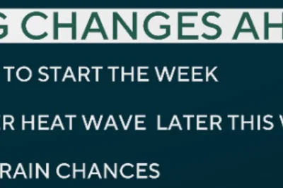
Weather tracking models indicate that humidity levels will rise again on Wednesday, bringing back stickier conditions and a return of storm chances.
>>> Philadelphia Braces for Another Heat Wave After Brief Cool Down
Temperatures are projected to climb into the low 90s by Thursday and Friday, increasing the likelihood of afternoon and evening thunderstorms later in the week.