An unusual upper-level atmospheric pattern known as an omega block is poised to deliver an early summer heat wave to central and eastern Canada in the final days of May 2026, threatening to break national temperature records for the year.
According to The Weather Network, daytime temperatures are forecast to climb into the low to mid-30s Celsius across the eastern Prairies, especially in southern Saskatchewan, by Monday.
>>> Memorial Day Weekend Rain Threatens East Coast Tourism and Businesses
Increased atmospheric moisture will push humidex values into the mid- to upper-30s, creating muggy conditions that hinder sweat evaporation and intensify the heat's impact on the body.
The current highest temperature recorded in Canada for 2026 stands at 33.5°C, set in Lytton, British Columbia on May 5.
Meteorologists indicate this milestone could be surpassed during the upcoming week.
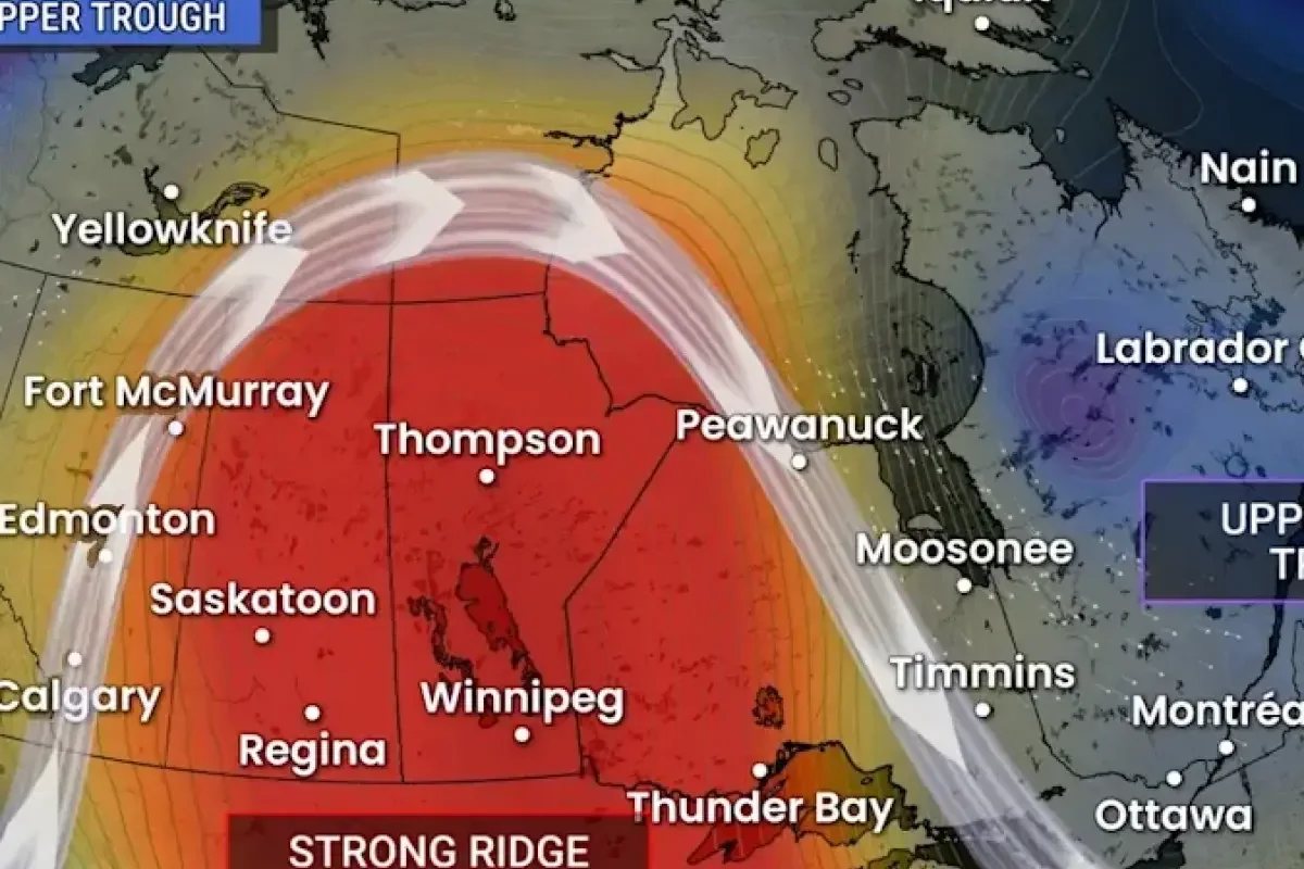
This major shift stems from an omega block, which forms in the upper atmosphere when a high-pressure ridge becomes locked between two low-pressure troughs, resembling the Greek letter omega.
This persistent pattern is difficult to dislodge and typically causes above-seasonal temperatures to linger for several days under the strong ridge.
>>> Washington Area Prepares for Memorial Day Weekend Events Amid Stormy Forecast
The intense warmth will attempt to push eastward into Ontario, raising temperatures into the 20s for a few days before a cool, unsettled trough over the Atlantic provinces alters conditions.
Consequently, northern regions of Ontario and Quebec are expected to experience warmer weather than their southern counterparts.
Before the heat arrives, active weather systems will generate widespread showers across the Prairies early in the week.
Precipitation is scheduled to hit the Atlantic region by Tuesday, with conditions clearing by Thursday as an upper-level ridge establishes itself and lifts late-week temperatures into the mid-to-upper 20s.
In contrast, Western Canada faces an unsettled end to the month due to an upper-level trough that will produce scattered, localized showers starting Monday in British Columbia and parts of Manitoba.
>>> Swiss Police Probe Home Invasion Targeting F1 Legend Alain Prost
Southern Saskatchewan will see heavier rainfall on Wednesday, followed by significant precipitation in eastern Alberta and Saskatchewan on Thursday, before the system moves into Manitoba on Friday.